The Hill of Uisneach – Geographic Center of Ireland
The Hill of Uisneach is located in the center of Ireland. Many believe the catstone atop the 600 foot hill mark the spot where Ireland’s five provinces – Ulster, Leinster, Connaught, Muenster and Meath – all come together. It is an ancient meeting place, and a place of high earth energy.

Lake at the top of the Hill of Uisnech
Most who drive down Route 390 going southwest of Mullingar in County West Meath wouldn’t realize they were passing such thin place. I know, because I passed it many times – and I was looking for it. But I found Uisneach. I climbed the hill. I was changed for having gone there.
When Traveling to a Thin Place – Listen for Signs from the Otherwold
Call it prayer, call it sensing … most of us know how to communicate spiritually. The present world reacts to the eternal world in a thin place. If we listen and look carefully, we can see the signs.
Many times I’ve been out looking for a particular place and find obstacle after obstacle thrown in my way… I get lost, there’s an unfriendly landowner, the weather becomes harsh ….almost sending me a message to suspend my search and retreat.
But I never do. Those signs only encourage me – let me know that the experience will be worth the obstacles – and my visit to Uisneach proved me right. There were many obstacles, but the Hill of Uisneach was the single most powerful place I’ve ever visited.
Uisneach – My Heaven and My Hell
The hill looks like many Irish hills from the road, but as the climber ascends to the crest the magic reveals itself. There are ring forts all over, and small lakes, wildlife, and if your senses are keen – many signs from the eternal world.
I was traveling alone when I visited the Hill of Uisneach. It was a damp day and the ground was soft. I had to stop in Ballymore and ask for directions. Once I found it and began climbing, I kept looking for the catstone, said to be on the top. The stone is said to mark the geographic center of Ireland and the grave of the goddess Ériu, for whom Ireland (Eire) takes its name. I never found the catstone… but my experience was rich.

Newgrange – Meet Me Here at the Winter Solstice

Tomb Entrance – Lintel Above the Door allows light passage into the tomb.
Newgrange passage tomb in the Boyne Valley – County Meath, Ireland is the oldest, fully in-tact building in Ireland, and probably in western Europe. According to Mary Gibbons who offers excellent tours of Newgrange, the tomb dates back 5000 years, predating the pyramids of Egypt, Stonehenge and all the other tombs and prehistoric enclosed structures in Ireland and Britain. Newgrange was a center for spiritual ritual and has remained intact since the Stone Age. The inside is large with a center chamber large enough for 20 people to stand and three side chambers. Early people of the Boyne Valley placed cremated remains in these side chambers.
If the Middle Ages had their cathedrals, the Stone Age had its passage tombs, and Newgrange is the equivalent of Rome. Mary Gibbons’ most memorable quote for me is, “Newgrange is the oldest building in the world still standing in its original form.” The “building” is what’s inside – the door, the descending path, the roof, the carvings, the walls, the side chambers. This was a feat of precision engineering. And 5000 years later, it still works.
Amazing.

Newgrange – Neolithic Passage Tomb
From the outside, Newgrange looks like a large, flat, round building with a grass roof and stone sides. These outside cosmetics are new and not part of the original structure. But the tomb itself and the entrance has not been altered. The entrance is dominated by a mammoth-size boulder with intricate spiral and diamond shaped carvings. One had to cross over this stone to gain entry.
Above the entrance to the tomb is a stone lintel which allows light to pass into the tomb on the Winter Solstice (December 21) – the shortest day of the year. Newgrange was built according to a specific blueprint that allowed for the tomb to be illuminated by the sun on the day when sunlight shines for the shortest amount of time. The illumination is a gradual beam of light that pierces the pathway into the tomb and shines across the floor. lasts approximately 15 minutes. Then total blackness sets in again … until the next year.
This illumination is simulated for visitors with a flashlight. Though it’s not “pure” light, it’s still pretty impressive to experience. Every visitor in that chamber is wondering the same thing …. “What would it be lie to be here at the Solstice?”

Ancient carvings of spiral designs were common in this age and region, but Newgrange has the rare “triple spiral” on both its entrance stone (shown below) and on the wall of the tomb. Who knows what the spirals meant?
Everyone wants to be at Newgrange during the winter solstice – including me. But to be present, you must enter the yearly lottery. Applications are at the Bru Na Boinne Visitor Center. If you can’t fill one out in person, you can email and request a staff person there fill one out on your behalf. The drawing for 50 lucky people (who are invited to bring a guest) happens in September. Last year there were 31,531 entries.

Dan Burgoyne examining one of the curbstones
Spirals and diamonds appear on other stones at Newgrange, including one of the curbstones around the back. Many have guessed at what the spirals mean. The best definition I heard was the the spirals symbolize how time passes – rather than linear, time is circular, like the seasons. While we live in this time we could be passing closely by those who lived before us and will live after us. Time turns – rather than passes.

Newgrange – coming out of the tomb
Though it’s against the rules to use any cameras in the tomb, I snapped this photo with my cell phone as I was exiting. It shows how narrow the path is. It’s amazing that all the calculations for building the tomb still fit, allowing the sun to penetrate the darkness on the Winter Solstice. Light must have been important to the Boyne Valley early civilizations. It was here that they built one of the greatest tributes to “light penetrating the darkness.”
Newgrange, along with the Hill of Tara and the surrounding Boyne Valley are the first stop on the Thin Places Mystical Tour of Ireland scheduled for May 2012.
We join Mary Gibbons’ tour and it is fabulous commentary as Mary is both an archaeologist and a historian, as well as a Western Ireland native with a cheeky sense of humor. Her tours are one of the highest rated in Ireland.
Check out this year’s itinerary and join us!
Uragh Stone Circle on the Beara Peninsula – Enchanting
")
Uragh Stone Circle on the Beara Peninsula – the Kingdom of Kerry
The Beara Peninsula which straddles Counties Cork and Kerry has some of the most mystical sites in Ireland scattered over its terrain. The Uragh Stone Circle, not too far off the main road from Kenmare to Ardgroom is one such site. The circle has 5 small stones and one large alignment stone. Surprisingly, this stone circle doesn’t appear in guidebooks or local destination publications. I only found it due to the signage along the roadside. This site is well worth traveling thousands of miles – just for the view and the energy in the place itself.
The circle rests on a small hill that sits between two lakes – Cloonee Lough Upper and Loch Inchiquin. The back drop is of mountains, veined by waterfalls. I noticed the colors of the mountains continually change as the ever-moving sunlight shifts. The effect is similar to a kaleidoscope with muted earth tones. Stand still and watch the landscape change.
")
The Road Approaching Uragh Stone Circle
A dirt road reaches the circle, and one must cross a bridge to get to the hillock. When I was there it was damp and muddy. Traversing up the hill to the circle required boots, but well worth the challenging mud holes. Standing on the hill near the circle I could see that this was the center of the vast landscape all around. The view over Loch Inchiquin is spectacular.
This spot is magical.
")
Five Stones of Uragh Stone Circle
The circle itself has 5 stones tangentially placed and one great alignment stone that appears to line up with the axial stone though very close in proximity. The massive alignment stone is over 10 feet high. It dwarfs every other element of the landscape.
It’s easy to imaging Uragh Stone Circle as a portal to another place or another realm. The changing light, the shifting colors, the solitary setting of the circle – all these elements consume the spirit. I lost track of time while there. After awhile a young couple walked up the dirt road from the opposite direction – past the circle. They said they’d been watching me from the hillside. I seemed so determined to reach the circle through the mud. So they came out for a walk. They were vacationing there on Beara for a week. When I asked where they were from, they replied Washington DC (just 35 miles from my home at the time).
Strange coincidences tend to occur in thin places.
Timoleague – Mystical Ruin on the Sea

Timoleague Abbey Ruin – County Cork
Along the road between Kinsale and Clonakilty, near Courtmacsherry is the village of Timoleague which is dominated by the great seaside abbey ruin, a remnant of a 13th century Franciscan Friary. The abbey is built on the site of a former monastery founded by St. Molaga in the 7th century. Timoleague means – “house of Molaga.”
St. Molaga, as the story goes was a local boy who went to study the rule of St. Columba in Iona and then went on to Wales where he became good friends with St. David. He returned to Ireland and founded several monastic communities, but Timoleague was his greatest – and his last. He died here – probably of the plague. He and his followers were committed to helping those suffering from the disease when the plague hit Ireland in the late 7th century.
A story is told about how St. Molaga originally wanted to build his monastery farther up the estuary. But as he and his followers labored on the buildings by day, they all collapsed by night. St. Molaga took this as a sign that the Lord did not approve of the location. So he blessed a candle, lodged it in a rolled up sheath, set it alight and released it on the bay praying that God would help him find the perfect location for his new religious community. The candle floated until it stopped at the where the Timoleague ruin now stands. St. Molaga built his monastery on the sea and six hundred years later the Franciscans built an abbey on the foundations of St. Molaga’s monastery. The ruins of that monastery are what visitor’s see today.
I found this thin place through the recommendation of Mr. Noel O’Connor who was my host at Ashgrove Bed and Breakfast in Bandon. Over breakfast I asked him, “What is the most mystical place around here?” He was caught off-guard and hesitated. As a forma garda (police officer) I suspect he wasn’t invited to discuss “mystical” or thin places often. After pausing to give it some thought, he told me that many pilgrims go to Timoleague to pray and reflect. So I took his advise and I went to Timoleague.
What remains is a beautiful ruin now made into a comfortable public space on the scenic Courtmacsherry Harbor. When the monastery was active, boats used to sail right up to abbey, and the village grew around the activities focused there. Past the picnic tables and the stone wall are bones of the old religious house with haunting traces of how life existed there so many years ago.

The Cloister Garth at Timoleague
Two favorite spaces for me were the dining room and the cloister walk. Pictured above is the cloister garth the part of a corner wall still standing. Monasteries typically had these square cloister walks with an open court-yard type garth in the center. The walks were the center of the the cloister and often used for doing “rounds” or walking and praying in a circular path. The walls bordering the garth had gothic-style windows to look out. I love to trace the steps of those who once walked and prayed here. On account I read said that at one corner of the walk the incorrupt body of a monk buried centuries before was discovered. He was reinterred on the grounds.
Another peaceful spot here is the refectory or dining area. It’s a large rectangular room off the back of the ruin with five tall windows (frames still in tact) looking out over the sea. Next to this area is a cavity wall, with indentations known as the fairy cupboards. It was from this room that children discovered an ancient book buried under one of the flagstones. They destroyed it and only the shred of the cover was found.

Cavity wall – the “fairy cupboards” In the distance is the tower of the Catholic Church
In the sacristy is the ancient holy water font, now known as the Wart Well. It is said to heal warts when those afflicted dip the warts into the water.
The monastery was sacked in the 1600s and three monks escaped by boat and took with them the Timoleague chalice for safe keeping. It was discovered in an old box in a home in the village many years ago and is now held by one of the priests residing in Timoleague.
In the distance behind the ruin a round tower (new) can be seen atop a church. This is the Catholic Church dedicated to the Nativity of the Blessed Mother. One of Henry Clark’s last stain glass masterpieces can be found here.
Timoleague is a haunting site full of mystery and charged with the energy of the past. It is one of the stops on the Thin Places Mystical Tour of Ireland in May of 2011.

The Wart Well at Timoleague
Holy House of ivied gables
That wert once the country’s pride
Houseless now in weary wandering
Roam your inmates far and wide
~from Lament Over the Ruins of the Abbey of Timoleague
John Collins -1814
Drombeg Stone Circle – County Cork

Drombeg Stone Circle – County Cork
The area in southwest Ireland – West Cork and much of Kerry – has over 100 prehistoric stone circles. What was the purpose of these circles and how were they used? One can only speculate. Reading the seasons, sacred worship, sacrificial offerings, astronomical clocks, burial grounds … these are just some of the uses the pre-Christian people of Ireland had for these stone circles. But there’s much more about the circles we still don’t know.
The circles in this region all have an odd number of stones. Drombeg has 13 – but it originally had 17. Most of the Cork / Kerry circles follow a specific astronomical orientation, having an axial stone (usually a lower, shorter stone in the circle) on the western edge opposite a set of entrance or portal stones (usually taller) on the eastern edge. The axial stone is also called the recumbent stone. In the photo above, the two portal stones are in the center of the photo and the lower, axial stone can be seen between them on the opposite side of the circle.
A Winter Solstice Light Show
You can barely see the little notch in the hills behind the circle, but the hills define a sort of “V” on the horizon. On the winter solstice (Dec 21 – the shortest day of the year), the sun dips just under the ridge of that V in the hills, but as the earth moves the sun comes into the V in near perfect alignment with the axial and entrance stones – shooting its concentrated rays directly across the center of the circle. Accounts by people who have seen this process state that it looks as if for a few moments, the circle itself is illuminated independently of the surrounding landscape.
Why would this process have been important to these ancient people?

The Portal Stones – Drombeg
The Ridge is Man-Made
Excavations around the site back in the 1950s showed buried human cremated bones near the center of the circle coupled with broken pottery shards and stones. There were other burial pits near the circle with the same combination. Oddly, the shards of pottery and the stones seemed to be as revered in burial as the human bones. Excavation also proved that the plateau where the circle rests (Drombeg means “small ridge”) is man made. The people who built this circle evidently leveled the land – or ridge – to affect the perfect winter solstice drama that occurred in the circle during sunset.
Prehistoric Huts Nearby
In the same complex, near the stone circle are the remains of two prehistoric huts that were probably used for cooking – what we might call a “commercial kitchen” today. One of the huts had a capacity to boil about 70 gallons of water. Hot rocks from a fire were placed into a rectangular stone basin and within 20 minutes the water would come to a boil and remain hot for about 3 hours. This was probably how the ancient people boiled their meat. Remains of what was probably an oven are in the second circular hut. This tells us that the area wasn’t just a place to read the seasons or practice sacred ritual. The circle would have been a place of community.

Prehistoric hut at Drombeg
The Drombeg complex is located between Skibbereen and Kinsale, and is easy to access with parking relatively close to the site. My first visit to Drombeg was in February of 2007. It was a cold, dreary, rainy day. I arrived tired. It was my last site of the day. The time was 5:00 pm. As I approached the site from the car park, I was unimpressed at first. The site seemed to have no sense of place. In fact, save for the shadows from the stone circle, the site looked like another farm field with houses nearby.
But as I walked into the complex and took in the surroundings, the place became magical. This is a site worth visiting. Take some time to gather your senses about you and notice everything about the surroundings – the distant hills, the views of the sea, the sounds, the light, the stones themselves. Then when your sensitivities are peaked, enter the circle through the Portal stone entrance.
The following is from my travel journal which is mostly transcribed recordings of impressions I dictated into a digital recorder during the visit.
I take back what I said about this site being unimpressive. The stone circle is beautiful. It’s in a big clearing where the entire valley just unfolds as you approach the circle. And there are views of the sea – the Celtic Sea.
There are hills and hills of green. Expansive sky. It’s a big wide area. It’s a beautiful stone circle. The stones are thick and tall.
Walking through the entrance of the Drombeg portal stones is pretty powerful. You walk in through the center and you can feel it. There’s just something sacred about the center of the circle.. I noticed the axial stone had two notches. There is energy here. Old energy. Ancient energy.
Drombeg Stone Circle is a very thin place. It is one of the stops on the Thin Places Mystical Tour of Ireland – May 15 – 24, 2011. Full Tour Itinerary. Make your reservations today.
Athassel Priory – Golden, Co. Tipperary

Athassal Priory
A few miles southwest of Cashel in County Tipperary lies the ruins of Athassel Priory, a 13th century monastery on about 4 acres of land. The ruins are haunting when viewed from the road. It’s a very thin place.
The Lonely Planet Guide to Ireland refers to Athassal Priory as “…the atmospheric – and deliciously creepy at dusk – ruins.”
The ruins are set in a large field one must access by climbing over a wall from the roadside (at least this was true the last time I was there). It’s a massive ruin, but it’s interesting that Lonely planet called it “creepy.”
Athassel is one of the few places I have visited (and I’ve visited hundreds of monastery ruins) where I got an overwhelming sense of foreboding. Can’t say why. The place was beautiful but in this one spot I started to feel frightened, almost terrified. I turned the corner and saw this statue carved out of the ruined wall – St. Joseph and the boy Jesus… but Jesus’ head was removed. I moved away from that section and continued through the ruin. The intense fear subsided, but felt like I was being watched the whole time.
")
St. Joseph and the boy Jesus
Strange. A very thin place.
The original buildings date back to 1205, and was founded by the Augustinians. Later it was occupied by the Cistercians. It’s original size alone denotes that it was a source of great wealth and a significant monastery in Ireland and it would have been surrounded by a large town – none of which remains. Still surviving within the ruin are an arched stone bridge approaching a portcullis gateway and gatehouse.
")
Athassel Priory bridge, portcullis gateway, gatehouse ruins
It’s easy to lose track of time at Athassel. One could wander for hours. The priory is a stop on our Thin Places Mystical Tour of Ireland scheduled for May 2011. Interested in attending? Check out the itinerary and book your spot.
Mount Brandon – Named for St. Brendan

Mount Brandon – the Holy Mountain of St. Brendan on the Dingle Peninsula
St. Brendan, one of the Twelve Apostles of Ireland, was a holy man and a navigator. He was born and raised in the Dingle area, and ordained a priest in 512 AD. Brendan was founder of several monastic settlements in Ireland, one being at the base of of a great mountain on Dingle’s north shore – now known as “Mount Brandon.”
The mountain was named after the famous St. Brendan, perhaps because he founded a monastic community here, or more likely because it was from the base of this mountain that St. Brendan launched his fleet of curraghs, filled with his followers, to set out on a seven year spiritually guided journey to find the “promised land” – the Isle of the Blest.
Legend states that St. Brendan climbed to the peak of Mount Brandon, looked across the Atlantic and saw the Americas. Many believe that Brendan reached North America way before Christopher Columbus, and several groups have alleged that Columbus referred to a manuscript that told of Brendan’s journey across the Atlantic. Much has been written about the Voyages of Brendan. What we know to be true is that Brendan grew spiritually on the journey and returned with the ability to draw large numbers into a deeper spiritual existence
St. Brendan is the patron saint of sailors and of travelers and is still reverenced in Ireland and around the Christian world. And the holy mountain, named for him, that dominates the northern landscape in Dingle is a reminder of where the journey began for a great spiritual leader, and where the journey begins – even today – for those that try to follow in his footsteps.
Brandon Head, the alleged launch site for Brendan and his followers, can only be accessed by foot. There is a pilgrim’s path that runs along the mountain that hikers and walkers traverse. The views from this trail are remarkable. But if you can’t take the walk, the views from Kilshannig, Castle Gregory or any of the strands off the northern road offer tremendous views. Often, the peak of Mount Brandon is hidden in the clouds.
Mount Brandon is a thin place. I had one of the strongest touches from the other world on a strand facing Mount Brandon. That story may come in another post.
Flickr photos for Mount Brandon.
St. Brendan’s Prayer
Shall I abandon, O King of mysteries, the soft comforts of home? Shall I turn my back on my native land, and turn my face towards the sea?
Shall I put myself wholly at your mercy, without silver, without a horse, without fame, without honour? Shall I throw myself wholly upon You, without sword or shield, without food and drink, without a bed to lie on? Shall I say farewell to my beautiful land, placing myself under Your yoke?
Shall I pour out my heart to You, confessing my manifold sins and begging forgiveness, tears streaming down my cheeks? Shall I leave the prints of my knees on the sandy beach, a record of my final prayer in my native land?
Shall I then suffer every kind of wound that the sea can inflict? Shall I take my tiny boat across the wide sparkling ocean? O King of the Glorious Heaven,
shall I go of my own choice upon the sea?
O Christ, will You help on the wild waves?
Drive Around Dingle – Slea Head
 One of the most scenic drives in Europe is the Dingle drive around Slea Head – the western tip of the Dingle Peninsula where glimpses of Slea Head and the Blasket Islands provide stunning sea views.
My favorite part of the drive is just past the Great Blasket Center. Across the water on sees the “Sleeping Giant” – an off-shore island that looks remarkably like a giant stretched out on his back with hands resting across his stomach.
Nearby on the hilly ground on the land-side of the road are abandoned potato farms, left when the blight hit, never to be reclaimed. Whether sunny, cloudy or pouring rain, the Slea Head drive offers the traveler or pilgrim a peaceful, scenic look that has been relatively unchanged for centuries.
Slea Head is marked by a life-size white crucifix with Mary and St. John standing by. It appears incredibly stark in contrast to the gray rock and earth behind it and the blue / white surf below it. The white statues stand out, identifying Slea Head to the fisherman, and on a clear day- even some islanders can catch a glimpse.
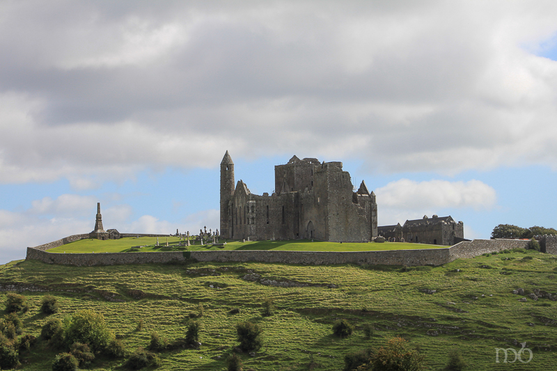
The Rock of Cashel – St. Patrick’s Rock
The Rock of Cashel Rises from the Golden Vale
The Pre-Christian and Celtic people of Ireland, Scotland, Wales and England had a keen sense for thin places. The landscape in these countries is littered with man-made markings and ruins that remind the passer-by that this is holy ground. The rocks, trees and landscape hold the memories of spiritual exercises here long ago and present.
Cashel is a thin place.
The very ground itself seems to call out, “Come here and be transformed.” In a quiet moment, the pilgrim today can sense a connection with the souls that have marked these spots with their spirits. Cashel is a vivid reminder that we are all joined inside and outside of time.
The Tipperary Plain also known as the Golden Vale, spreads like a quilt of green and gold velvet patchwork, delineated by hedgerows, lines of trees and occasional roadway, and framed by distant Slieve Bloom Mountains. It’s called the Golden Vale because of the rich, fertile soil which brought prosperity to those who farmed it. Out of the center of the Vale, rising some 200 feet is the Rock of Cashel.
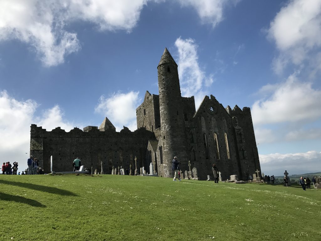
Crowned with the ruins of 11th and 12th century buildings, the Rock is woven into a series of legends, all associated with power and dominance that span nearly two thousand years. The Rock is also referred to as “the Devils Bit.” According to Irish legend, the devil was flying home (presumably to England) when in a fit of anger he bit off a piece of the Slieve Bloom Mountains and spewed it out into the middle of the Tipperary Plain, creating the Rock of Cashel. There is a unique “vacancy” in the hills around Cashel that looks decidedly like a bite. But the Slieve Bloom are comprised of sandstone and the Rock of Cashel of limestone, so the Devil’s Bit theory is unlikely.
St. Patrick’s Rock
Legend states that St. Patrick preached here in the fifth century. He came to convert King Aengus and baptized the King around 450 AD. Patrick later made Cashel a bishopric claiming it as a seat of power long before it was the seat of the high kings of all Ireland.
 In the twelfth century, a high cross, now known as “St. Patrick’s Cross,” was erected at Cashel to commemorate 800 years since St. Patrick’s visit. The original cross is quite weathered, but the image of the crucified Christ on the west face and the image of a man (possibly St. Patrick) on the east face can still be made out. The cross rests on a massive base repudiated to be the coronation stone of the Kings of Muenster. A replica of the cross and base greets visitors as they enter the enclosure on the Rock. The original cross and base are in the museum – also known as the Hall of Vicars, which also serves as the Visitor’s Center.
The Rock, called Cashel of the Kings – Cashel is Irish for stronghold – dominates the surrounding landscape, its drama unparalleled in Ireland, and its history is every bit as dramatic. For one thousand years it was the seat of power for Irish kings and bishops, ruling the surrounding country, and for a time, the entire country. For 400 years it rivaled Tara as the seat of power for all of Ireland. The kings of Munster were crowned here and ruled from Cashel. In 978, Brian Boru declared himself High King of Ireland and was crown on the Rock of Cashel. He made Cashel his capital. Brian Boru was the first to unite all of Ireland with its centuries-long history of warring clans and tribes. He was also the last to unite all of Ireland, for since his death in 1014, no one person has unified the populations in all four provinces.
Boru’s descendants ruled from Cashel for one hundred years after his death when Murtagh O’Brien in 1101 gave the Rock of Cashel to the Catholic Church and it began to thrive as a Cathedral.
In 1647 the Earl Inchquin (under Cromwell’s influence) plundered the city. The townspeople fled to the Rock for safety and barricaded themselves in the Cathedral. Inchquin’s army piled turf around the cathedral and set it afire. All inside were burned to death. Over 800 people perished under that attack. The Rock was later abandoned, left to fall further into ruin. Finally, in 1874 it was declared a national monument and since then has been lovingly restored.
I will never forget the first time I saw the Rock of Cashel.
 At 10:00 a.m. we came down the Tipperary Road into Cashel. Seeing the Rock emerge from the landscape stirred childhood memories of seeing Emerald City rise up at the end of the yellow brick road in the Wizard of Oz. It was a moment when time stood still, burned in my memory like a trauma or birth.
That day we climbed the Rock of Cashel and wandered through the Cathedral ruins and cemetery. I knew nothing then about the history, who lived there, who ruled from there, what events took place there, but I knew it was a thin place. There was something exhilarating about Cashel, an excitement, a sense of power.
Cashel has long been linked with power. Warriors, chieftains, kings, princes, saints and bishops have all come here to mark the Rock as the seat of power, and blood has been spilled in that struggle for power. The Rock is not a peaceful place – as its legacy is riddled with memories of those who fought for power, stole power, ran to take refuge under the mantle of the powerful, and those who gloriously won the power.
The thinness is palpable. Your spirit is awake at Cashel.
I have returned to the Rock of Cashel with every visit to Ireland. I have seen the Rock lit up at night, covered in rain and mist, set against the frigid winter landscape and lingering through the long days of summer where the sun barely sets before rising again.
The Rock of Cashel, though in ruin, has a constancy; a historic brilliance that defies the modernization that grows around it with new homes, buildings and roadways. Cashel boldly claims her history, memories of kings, chieftains, warriors, bards, and holy men – thrusting them before us, urging us to enter in to her ancient legacy – and to return, and return and return.
So many people ask me, “What should I see on my visit to Ireland?”
I always say, “Don’t miss the Rock of Cashel.” Sadly, only a few heed my suggestion.
What a pity.
They’ll never know what I know… that Cashel will seduce you like a lover and cling to your spirit, planting some small charm that draws you back to her, creating a hunger for reunion. With each visit your are strengthened and sustained … until the next time. Cashel is like a first love. Though time, distance and life experience may stand between you – you never forget her, and you will return to her over and over in your imagination. You are changed forever for having known her.
Skibbereen Famine Cemetery – a thin place
 Abbeystrewery Cemetery in Skibbereen. 8000 – 10,000 victims of the Great Hunger are buried here.
Skibbereen was a hub of commerce in southern Ireland during the nineteenth century, with the River Ilen flowing through the town ending at the Baltimore Harbour near the Atlantic Ocean. But Skibbereen is perhaps most famous for its association with the Great Famine that hit Ireland hardest in 1846-47. The song Skibbereenwith a haunting melody and lyrics that tell of a father recounting to his son the cruel reason why he left his beloved homeland “old Skibbereen,” – he lost the farm, the house, and he lost his wife to hunger when the boy was but 2 years old. So the father fled with the young son wrapped in his coat – never to return for fear of being imprisoned for the debt he owned in taxes and rent. County Cork was one of the areas in Ireland that lost over one third of its population to the Famine in those years.
History states that the Famine occurred because of a failure in the potato crop in Ireland. The Irish were under British occupation at the time. Rich landlords controlled the country, though they were a small portion of the population. Most of the population served as tenants to these landlords, and suffered from high rents and taxes. Poverty ran deep in the tenant class, which used the potato as the main staple of its diet. When the crop failed, panic set in. The Irish sold what they had, including boats and fishing equipment to feed their suffering families. One in three people died in the area surrounding Skibbereen. Most concur that there was plenty of food in Ireland – plenty enough to feed the starving citizens. But the food was exported for profit that was made by the British government and the Anglo Irish ruling class.
 Sketch by illustrator James Mahony entitled – Skibbereen 1847 – Mahony produced this for a London newspaper in the same year
People were dying so fast in Skibbereen that there weren’t enough people alive to take care of the task of burying the dead. So a mass grave was dug near the ruins of the old Abbeystrewery Franciscan friary. It is estimated that 8,000 to 10,000 nameless, coffinless, unremembered dead were dumped into the mass grave. Today the lumpy plot of ground has green grass covering the burial site and a stone marker that says:
In Memory of the Victims of the Famine 1845-48
Whose Coffinless Bodies were Buried in this Plot
There is a commemorative Famine trail that begins at the town center and includes the Skibbereen Heritage Centre and the Abbeystrewery Cemetery (pictured above). The artistic renderings of stone cutters and poets that dapple the cemetery grounds with tokens of remembrance are worth a trip to Skibbereen. So much sorrow here. One can’t helped but be moved.
Skibbereen is a thin place. And it is a stop on our Thin Places Tour in September 2010.