Grianán of Aileach – the Sun Palace

Grianan of Aileach – County Donegal
Grianán of Aileach or Grianán Ailligh is a cashel on the Inishowen Peninsula in County Donegal. Also known as the “Sun Palace,” it was the royal citadel of the northern Ui Néill (O’Neills) from the 5th to 12th century.
The Cashel
The cashel dates to the third century and archaeologists suspect it could have been built on a former Neolithic sacred site or burial mound. Experts in Irish culture and heritage believe that the mound was used for ritual purposes as far back as 1700 BC and was the center of one of Ulster’s ancient kingdoms – and later the political center of the ruling O’Neill’s and later the O’Donnells. This would have been the royal center, where kings were crowned and rituals carried out as well as a defensive structure.
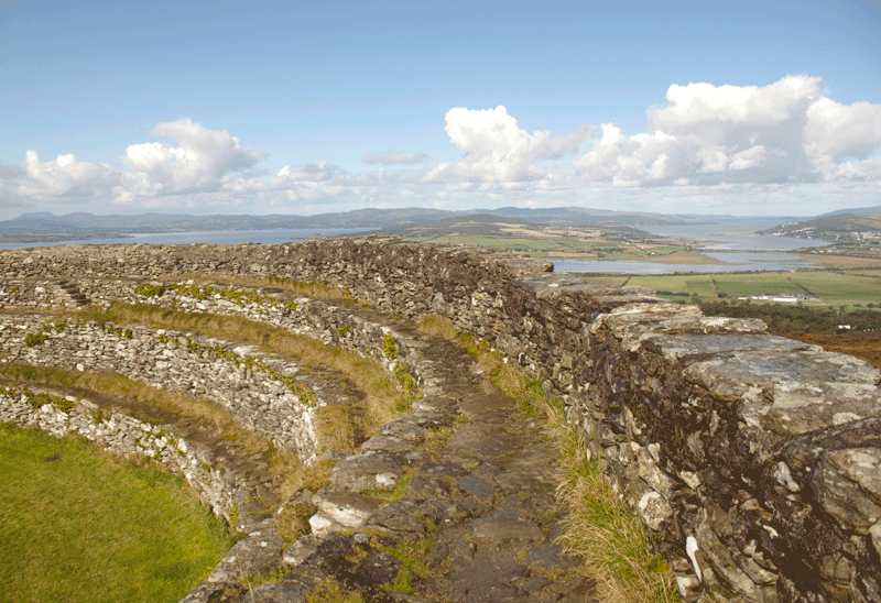
Though the actual ring fort was probably built in early Christian times, the three concentric rings surrounding the cashel as well as artifacts discovered in the surrounding rings suggest this spot was used for ritual much earlier. The cashel itself is 77 feet in diameter and its walls are 13 feet thick with chambers embedded. Inside the circle are stairways built into the inside walls the lead to ringed seating areas – like an amphitheater. This seating gallery would hold hundred of people who could witness inaugurations and other ritual ceremonies.
Inside the Grianan
The City of Derry’s website has a video embedded that was filmed inside the cashel and shows a reenactment of a medieval celebration
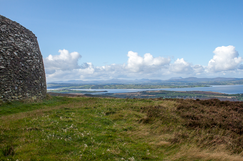
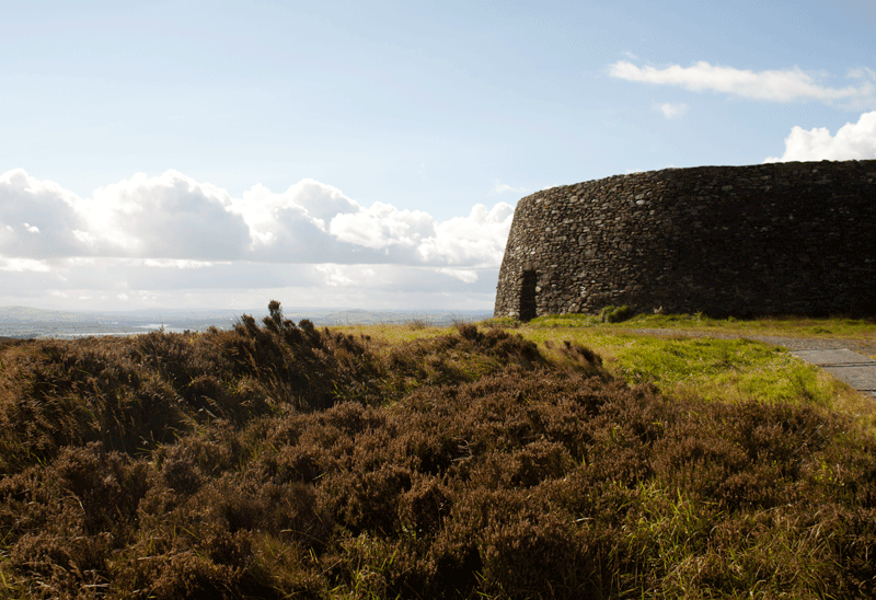
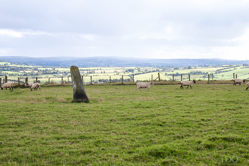
From the top of the ring one can see for miles in every direction. Counties Tyrone, Donegal and Derry are in view with mountains, cliffs, open pastures, villages and beaches. Lough Foyle and Lough Swilly, the two bodies of water that flank the Inishowen Peninsula swirl about in that landscape. The peninsula rolls out like a blanket from this vantage point, eventually vanishing in a misty gray horizon (on a sunny day, that is). It’s easy to understand how the cashel on dominated the region and became as the political center. Its remarkable disk-image capping a hill 800 feet above sea level is visible to so much of the surrounding countryside.

The view from the cashel
Tied to Celtic Mystery
Folklore suggests that prior to the cashel, this hill was associated with deities linked to the sun. In Irish “Ail” refers to stone. Grianán in Irish means “sunny spot” or sun temple. So the name could refer to a stony sun temple or palace. But according to author Cary Meehan who wrote Sacred Ireland, it can also mean sunny disposition or of the sun. In Celtic mythology Grainne was the sister of Aine – goddes of the sun, and though Grainne was known as goddess of corn or grain (springs from the earth after being nurtured by the sun), both sisters are said to have been birthed by a sunbeam or “of the sun.”
There is also a tradition that the temple was built by Daghdha, the good god or god of the earth. He was known as the King of the Tuatha dé Danann, a race of supernatural beings descended from the Goddess Danu. They inhabited Ireland before the Celts. This tradition has Daghda building the fort to protect the grave of his son. A variation tells of giants building the hill and the Grianán on top a residence for the shining ones who gave birth to the children of the sídhe. All of these traditions link the hill and the fort on top with supernatural beings, to unseen energy and power and a link to the Otherworld.
Cashels were built for defensive purposes, but circles are also linked to Irish ritual and spirituality. The shape represents a deeper meaning. Stone circles, carved spirals on implements and burial stones, circular mounds covering passage tombs indicate this. There was also a later belief that circular buildings had no corners for evil entities to hide. Thus one can’t dismiss the spiritual importance of Grianán of Aileach, even though the cashel marked it as a secular site. The traditional beliefs embedded in the Irish life permeated all they did. This circular fort sitting atop three concentric circles on a circular hill was built with circles in mind. And the site has a powerful energy about it.
Originally the cashel had been the stronghold of the 4th century chieftain, Niall of the 9 Hostages. Later it became the stronghold of the O’Neill kings and the O’Donnells. The cashel was mostly destroyed in 1101 by the king of Munster, Murtagh O’Brien and his army in retaliation for the O’Neill’s destruction of his palace in Clare (Kincora). After they sacked Grianán of Aileach, Murtagh O’Brien told his army of a thousand men to each take a stone from the cashel with them so that the fort could not be rebuilt.
The cashel was later restored again in 1837 by a Dr. Bernard from Belfast. And in 2007 the Irish Office of Public Works restored it to the excellent condition it is in today. Some say it is over restored. But over-restoration has not blocked the ancient energy that still apparently seeps from the ground and surroundings.
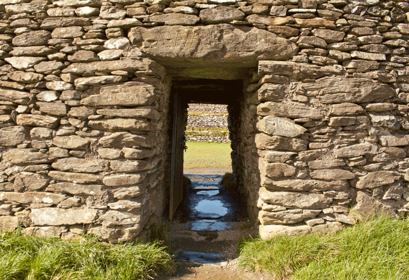
Grianan of Aileach Entrance
The Energy Linked to Grianán of Aileach
Irish Musician, Tommy Makem in his book Tommy Makem’s Secret Ireland wrote about his experience in trying to tape a television interview with Derry songwriter, Roy Arbuckle inside the cashel . Arbuckle laughed and told Makem that they’d never be able to record inside the walls. Makem couldn’t see any reason why it shouldn’t work.
But it didn’t work. Within a minute the sound engineer notice erratic movements on the meters which he couldn’t correct. The struggle continued for an hour and a half. They finally eked out 15 minutes worth of an interview, and as soon as they were done, all the batteries went dead. Somehow, Arbuckle expected this difficulty. Makem writes, “Roy seemed to understand the workings of some hidden forces in this magical place. He was chucking all the way back to Derry.”
It is true that Grianán of Aileach has an energy about it. One feels it on the walk up the hill to reach the cashel. It’s mad windy on that hilltop but as soon as you enter the linteled doorway into the ring, all the sounds of wind cease. Everything is suddenly still, and there is a strange silence. As soon as I crossed that threshold my imagination moved immediately to those who were in this space before… the sounds, the voices, the cheering, the shouting almost as if an old movie was playing in my head.
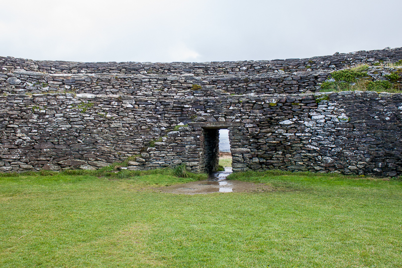
The entrance into the cashel is a threshold the opens into a place of different energy.
Over-restored or not, that energy is still present and the views of the surrounding landscape are some of the best I’ve seen in Ireland. Standing on the top level of the cashel ridge I surveyed the breadth of three counties – their pastures, mountains and Loughs Foyle and Swilly. The oneness of Ireland then and now is knitted together in that view.
One can see the approximate location of Rathmullen, a village on the west bank of Lough Swilly. It was from there that Hugh O’Neill and Rory O’Donnell left on a French boat bound for Spain one midnight in September of 1607. With 90+ relatives they sailed out of Lough Swilly changing the Irish social and political landscape forever. It marked an end to the old Gaelic order. An order of Chieftains and clans and common beliefs and the practice of rich traditions rooted in an ancient time.
And behind the fleeing earls was Grianán of Aileach, a remnant of old Ireland. In its time it was a great royal center, second to the Hill of Tara. An ancient road links them to each other. There is a legend of a cave in the hill beneath the cashel where the horsemen of the Great Hugh O’Neill rest in a magic sleep in full armor, mounted on their horses. The sleeping spell will only be broken when the next destined leader of Ulster arrives to lead them to victory.
So it seems there’s still a little magic left at Grianán of Aileach.
Sources used for writing this post:
A Traveler‘s Guide to Sacred Ireland by Cary Meehan
Tommy Makem’s Secret Ireland by Tommy Makem
Legendary Ireland by Eithne Massey
Mythic Ireland by Michael Dames
National and Historic Monuments of Ireland by Peter Harbison
Celtic Myths and Legends by Peter Berresford Ellis
Goddess Alive!: Inviting Celtic & Norse Goddesses Into Your Life by Michelle Skye
From Inishowen Buncrana Calling, the Heritage of Eoghain website by Brian Lace
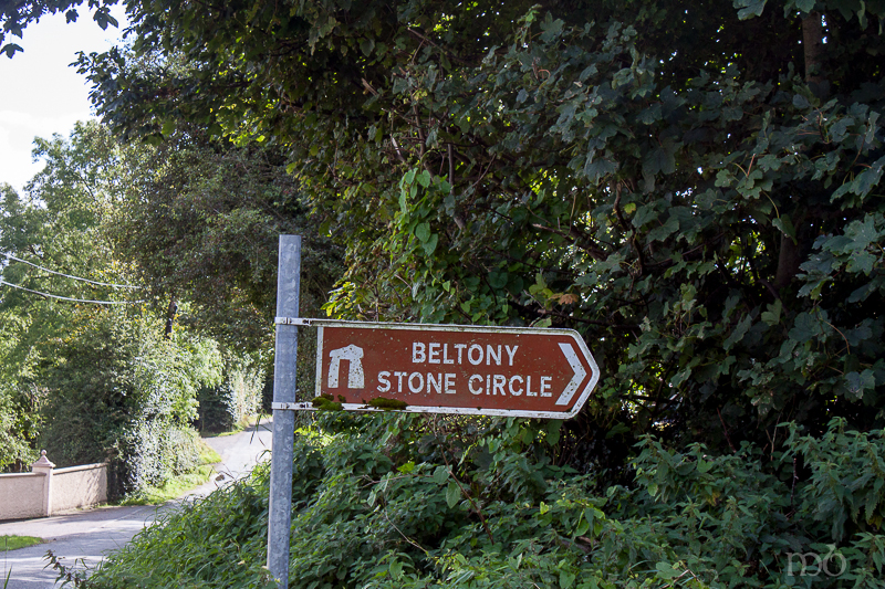
Beltany Stone Circle – Thin Place in Co. Donegal
 If a thin place is one where the veil between this world and the eternal world is “thin,” then Beltany Stone Circle in County Donegal ranks as one of the thinnest or most mystical sites in all of Ireland.
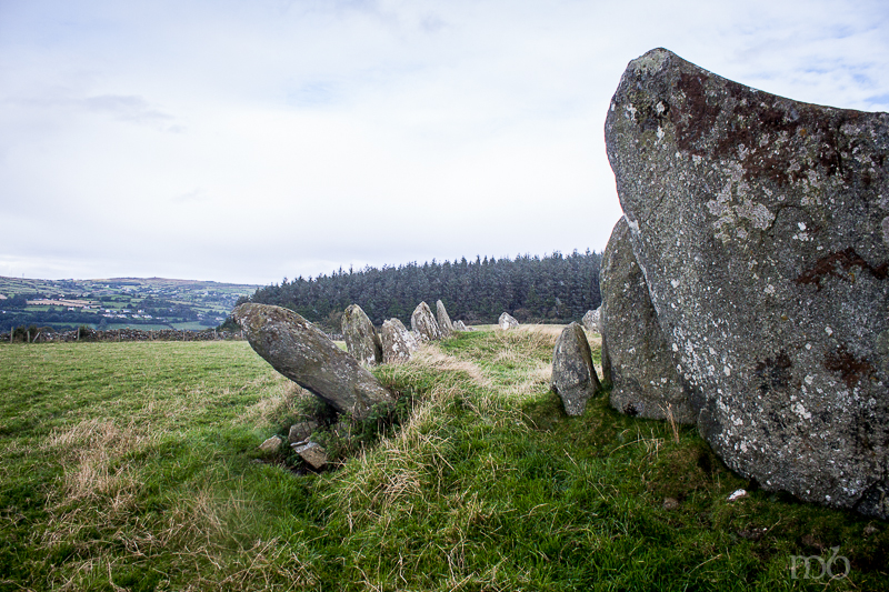
The circle dates back to 1400 – 800 BC, and is larger than most found in Ireland having 64 stones averaging 6 ft. in height. The circle measures about 145 feet in diameter. The site was excavated in the early twentieth century and significantly disrupted. Most believe that there were at least 80 stones in the original circle. These stones are orthostats – stones set against a rise or wall. They stand close together hemming in a raised earthen area resembling a kind of kerbing as seen in passage tombs. Some suspect that the circle and its center mounds could have comprised some kind of burial site that may have once been covered with earth. Others think the center “lumpiness” is a result of the disheveled condition the excavators left the site in back in the early 1900s.
The name Beltany is an Anglicization of the Irish word Bealtaine which is the feast of fire or rekindling the sun. Bealtaine festivals are celebrated on May 1st which is also the beginning of summer in the Celtic year. May 1st is the halfway point between the Spring equinox (the day when light and darkness are equal in hours) and the Summer Solstice (the longest day of daylight). The rituals on this day were linked to fire, particularly on hill tops across the landscape. Some believe this was a kind of refueling or re-firing the sun, or a form of worship that called down a blessing on the land and crops from the god of the sun.
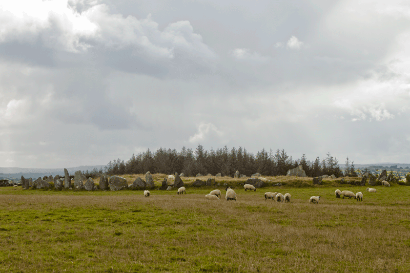
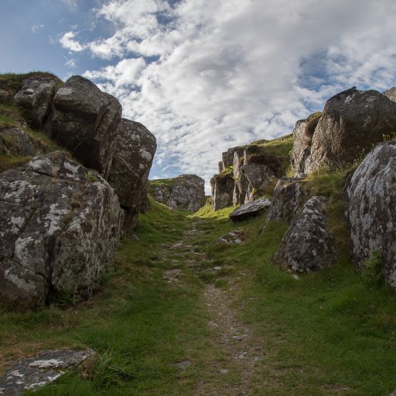
The circle as it comes into view from the wooded path.
The Beltany stone circle is located on Tops Hill. A wooded path (often muddy) leads from a car park to the summit. At the end of the shaded path, the landscape opens wide and in the distance, in a lone field one can see the jagged points of stones in a large stone circle. The transition from path to field feels much like a portal. There is a defined energy in this fields that grows stronger as one approaches the circle.
But there are two interesting stones in the circle that suggest it was used for measuring the seasons using astrological alignments, and possibly used for rituals related to the sun or sun god. These would be the tallest stone in the circle and the widest – the triangular stone with cup markings.
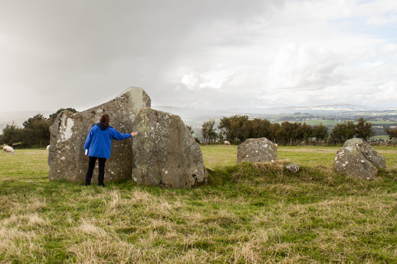
The triangular stone with cup markings
Most of the stones are tall and cylindrical in shape listing to one side or the other of the circle line. They resemble jagged old teeth. But the wide triangular stone, stands out. It’s special and immediately draws the eye. Additionally, it has cup markings on the inner face carved into it long ago. It faces ENE and stands directly across the circle from the tallest stone (about six feet high) which points WSW. When the two stones align they point to the summit of a hill about five miles away in Tullyrap – a summit where the sun rises directly over on May 1st – the feast of Bealtaine.
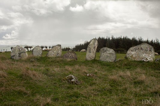
The tallest stone in the circle is center.
There are also noticeable outliers which may also have had a significance. According to Cary Meehan in her book A Travelers Guide to Sacred Ireland, “a line from the tallest stone in the south western part of the circle taken through the outlier, goes 28 miles south east to Bessy Bell Hill in Tyrone. Another line could run through the circle to Croaghan Hill, 4 miles ESE. ”
The Outlier – Beltany Stone Circle
So Beltany Stone Circle could have been a passage tomb(s) or a tool for charting the agricultural seasons. It may have been aligned with other sacred sites. We know it was used for celebrations specifically linked to Bealtaine. Three carved stone heads dating to the Iron Age were found at Beltany during the excavation. They indicate that the circle was used for many centuries.

The view from Tops Hill.
Today, though it’s been disrupted and disheveled, it still sits in place – marking the spot so many believed to be sacred. There site is still charged with energy. Even in the pouring rain, it offers a sense of thinness, of being in two worlds at one time.
Beltany Stone Circle is on the Images in the Landscape Tour in 2018.